


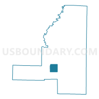
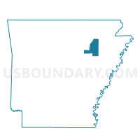
Horseshoe Voting District, Jackson County, Arkansas
About
Outline

Summary
| Unique Area Identifier | 526785 |
| Name | Horseshoe Voting District |
| County | Jackson County |
| State | Arkansas |
| Area (square miles) | 9.47 |
| Land Area (square miles) | 9.40 |
| Water Area (square miles) | 0.07 |
| % of Land Area | 99.25 |
| % of Water Area | 0.75 |
| Latitude of the Internal Point | 35.51060510 |
| Longtitude of the Internal Point | -91.27763690 |
Maps

Graphs
Select a template below for downloading or customizing gragh for Horseshoe Voting District, Jackson County, Arkansas


Neighbors
Neighoring Voting District (by Name) Neighboring Voting District on the Map
- Auvergne Voting District, Jackson County, AR
- Ingleside Voting District, Jackson County, AR
- Island Voting District, Jackson County, AR
Top 10 Neighboring County Subdivision (by Population) Neighboring County Subdivision on the Map
- Union township, Jackson County, AR (7,518)
- Breckenridge township, Jackson County, AR (478)
- Bryan township, Jackson County, AR (106)